The Baltimore Blueway will promote public access, public health, tourism, art and culture, and environmental stewardship.
Bringing it to life will take vision and collaboration.

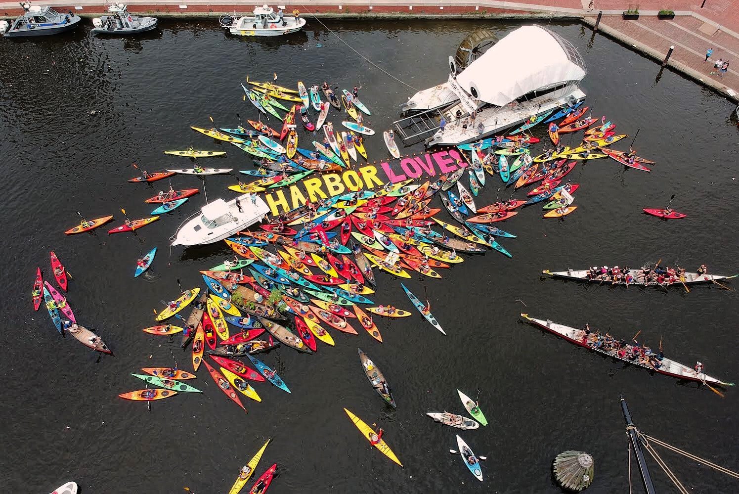
Paddlesports are coming back to the waters of Baltimore.
The Baltimore Blueway is a network of water trails and public access points for non-motorized craft that will connect cultural, historic, and natural sites throughout the Baltimore waterfront and promote an exciting new way to experience our city.
Imagine yourself gliding alongside historic ships, seeing the skyline from the water, paddling up to historic Fort McHenry, getting a selfie with Mr. Trash Wheel, or immersing yourself in nature, surrounded by wetlands and wildlife. Nowhere else in the Chesapeake Bay can you find such a diverse range of awe-inspiring paddling experiences within a 3-mile radius. By combining the marketing power of these attractions with outdoor recreation, the Baltimore Blueway will spur tourism and revitalization, bring together communities, and promote healthy lifestyles.
The Baltimore Blueway will also provide communities that have been disproportionately impacted by physical, social, and economic barriers with improved recreational water access and return a once highly polluted urban waterway to the residents whose tax dollars have funded its restoration.

The Waterfront Partnership of Baltimore prepared the Baltimore Blueway plan alongside our partners BioHabitats Inc., Toole Design Group, LLC, and REJ & Associates, Inc. The Baltimore Blueway is the culmination of a year-long project that included desktop and field analyses and stakeholder input to characterize existing and potential access points and rest stops and recommend a series of routes or trails.
The Baltimore Blueway heralds a transformative opportunity for our city, state, and region. By collectively embracing this project, we are not just bringing water recreation back to the Baltimore Harbor, but also fostering a sense of community and promoting sustainable urban development.
Is the Harbor Clean Enough To Go Kayaking?
Short Answer: Yes, Most of the time!
Long Answer: Thanks to over a decade of cleanup efforts, we have reached a point where we can now manage the Harbor as a recreational resource for the City. As with any public waterway, users should avoid contact with the water for at least 48 hours after a heavy rainfall. This is because rain carries pollutants off the land and into the water where they take time to dissipate.

PROJECT PRIORITIES
This plan is a snapshot of current conditions and is intended to be dynamic and adjusted as new information becomes available or opportunities arise to establish new/additional access points. For example, new shoreline development presents ideal opportunities to add new access points along the Blueway trails.
-
The Baltimore Blueway offers so many things to see and do, but nowhere are the attractions more exciting and in closer proximity to one another than in the Inner Harbor. In fact, there’s so much to see that finding space for a kayak launch can be a challenge. The Blueway Plan has identified the promenade adjacent to Rash Field as the most suitable location due to its onsite parking and accessible loading/ unloading area.
-
The Middle Branch connects the historically underserved communities of Brooklyn and Cherry Hill to the waterfront. The existing boat ramp and fishing piers located at Broening Park are in dire need of repair and replacement. It is recommended that a beach launch be added to the park to separate paddlers from motorized craft using the boat ramp.
-
The Baltimore Waterfront has ten water taxi stops owned by the Baltimore City Department of Transportation. Many stops include piers and floating docks that could be adapted to accommodate paddlers. In fact, many paddlers already use water taxi stops. Just as city streets provide separate lanes for vehicles and bicycles, creating designated launching areas at water taxi stops would separate these uses while supporting multiple forms of transportation.
-
Providing a soft beach at Canton Waterfront Park would allow paddlers to more easily get on and off the water while improving safety by separating them from the motorized craft using the boat ramp.
Access Point Priorities:
Marketing & Promotion Priorities:
-
Use social media, a website, a public relations firm, and partnerships to spread the word far and wide about the Baltimore Blueway. Celebrate new access points and major improvements with media advisories, social media posts, and press conferences as appropriate. Develop printed collateral to be distributed to partners like VisitBaltimore, downtown hotels, community groups, paddle clubs, and other users. Host paddle events and safety trainings to promote the Blueway to new and future users.
-
The Baltimore Blueway is an opportunity to brand and market paddling in the Baltimore Harbor while providing important safety information to paddlers. A compelling website will increase use of the Blueway by providing information about existing water trails and access points while also promoting the larger Blueway vision. The website should also provide timely updates on water conditions.
-
Each access point along the Baltimore Blueway should have prominent signage installed that identifies it as part of the Blueway and provides important information to users including safety information and wayfinding instructions for the Blueway trails and nearby attractions.
-
To ensure easy access to paddlecraft, equipment rental companies are needed. Providing basic infrastructure such as bathrooms, kayak launches, kiosks, and storage at highly trafficked areas along the waterfront will entice rental companies to locate on the Blueway.
-
Fort McHenry is already one of the most popular paddle destinations in Baltimore. While it is easy to paddle around Fort McHenry, it is not currently possible to dock and visit the site. The Blueway Plan envisions Fort McHenry as the connecting point between the Baltimore Blueway and the national Chesapeake Bay water trail network, including the Captain John Smith Chesapeake National Historic Trail and the Star-Spangled Banner Trail. This will involve building infrastructure for launching kayaks and providing rental equipment during the park’s regular operating hours.
-
This newly constructed recreation center in Baltimore’s Cherry Hill neighborhood sits on the banks of the Patapsco River but does not currently provide access to the river. River access would help connect Cherry Hill residents to the river and the many miles of nature-filled wetlands that line its shores. The Center could also provide programming on the river to teach residents how to paddle and use the Blueway.
Partnership Priorities:

Proposed Access Points
Proposed Access Points are identified as additional elements of the Baltimore Blueway and should be implemented as opportunities and resources become available. These sites will create a more comprehensive Blueway with access points at regular intervals throughout the Baltimore Harbor. A map showing the distance between existing and proposed access points is included in Appendix B and underscores the importance of continuing to populate Baltimore Blueway access points to improve safety and community access. Proposed Access Points are described below and summarized in Table 1.
Proposed Access Points are sites that lack basic paddler access infrastructure (i.e., the ability to easily launch a kayak from the shoreline) and/or do not have public access.

Proposed Rest Stops
Rest Stops include sites where paddlers can stop along the way to enjoy site amenities such as a picnic area or restaurant. Rest Stops tend to have limited parking available, and it is assumed that paddlers would temporarily anchor or store their personal watercraft while taking a break or visiting a nearby destination such as a restaurant. One such option for kayak storage at Rest Stops includes kayak lockers that can be rented and unlocked via a smartphone app. Rest Stops are placed at points of interest and are typically ideal location for rental facilities, which would eliminate the need to transport paddlecraft.

With significant investment, the Baltimore Blueway will open the door to multiple local, regional, and federal resources that will both enhance the experience and multiply the impact of the investment. The Baltimore Blueway launches an exciting new opportunity for our city, state, and region. Together, we will bring water recreation back to the Baltimore Harbor.


